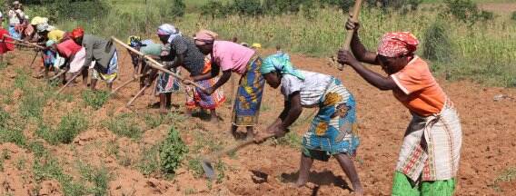
Drought drives change in agriculture for Angola
Onlangs heeft het Netherlands Space Office (NSO) twee nieuwe projecten goedgekeurd voor subsidie binnen het Programma Geodata for Agriculture and Water (G4AW). Beide projecten verbeteren de voedsel- en inkomenszekerheid van vooral kleinschalige boeren. In totaal zullen ruim 200.000 landbouwers in Ghana en Angola de nieuwe - op satellietdata-gebaseerde - informatiediensten kunnen benutten.
Developing information services
"Drought does not affect every part of Angola. The worst droughts happen in the south. The centre of the country is less vulnerable. Mavo Diami means ‘my country’ in the local Kimbundo language. The group carrying out the project is developing information services that help around 100,000 farmers in Many Angolan regions. Access to these services will be mainly via their mobile phones. They will get information on what to plant, when to sow, fertilise, water and harvest. Meteo weather forecasts and remote sensing data are transformed into voice messages and SMS alerts. These are then sent to call centres and agents", summarises Willianne van Slooten, Dutch project leader at World Vision. Mavo Diami started in September 2019 and expects to roll out its services in autumn 2020. There has been a delay due to local coronavirus measures.
Seeing problems in advance
Joost van der Woerd, a remote sensing specialist at project partner eLEAF, explains the concept. "By using satellite data, we can monitor crop performance like growth and water consumption. For this, we also look at the Water Productivity Database (WaPOR) from the United Nations Food and Agriculture Organization (FAO)." WaPOR is an open-source and near real-time data portal. It uses satellite data to monitor agricultural land and water productivity. The Dutch Ministry of Foreign Affairs subsidises WaPOR.
"Even if you cannot see it yet on the ground, with satellite data, we can see problems up to 2 weeks in advance. We do this by monitoring the water consumption of the crop. The farmer gets told about potential problem areas on time. This means they can act quickly to minimise damage to the crop. Satellite data can help with planning hired help more effectively. It can also help with reducing the use of water, pesticides or fertilisers, as application timing and requirements are optimised."
Geodata for Agriculture and Water (G4AW)
Through the grant programme Geodata for Agriculture and Water (G4AW), the Dutch Ministry of Foreign Affairs supports many smart agriculture projects in Africa and Asia. The projects help smallholders adapt better to climate change by using satellite data. The Dutch partners in the Mavo Diami project are World Vision, Aequator Groen & Ruimte, eLEAF, FutureWater and Weather Impact. The Angolan partners are the Angolan Ministry of Agriculture and NovaAgrolider. NovaAgrolider will be the primary business owner of the Mavo Diami enterprise. The enterprise will be established during the project. The G4AW Programme is carried out by the Netherlands Space Office.